


PPM Commander - GPS status

คำอธิบายของPPM Commander - GPS status
Connect your external GPS device by USB or bluetooth. Route the GPS position as mock location provider to any navigation app on your phone or tablet.
Show GPS status data like position, height, accuracy, satellites, velocity, etc.
You can forward RTK correction data to your high accuracy external device. RTCM data is loaded from the internet by the internal NTRIP client.
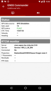
The app ist completely free with the exception of the NTRIP-RTCM feature. If you want to forward RTK data from your data provider (e.g. land surveying office) to the external GPS antenna, please license the app. You can fully test the NTRIP feature in advance within the 30 days trial period. You can view received RTCM message-types and coordinate-projection-parameters of the RTK data on the RTCM monitor page.
PPM Commander supports devices from ppm GmbH only, eg. ppm-10xx!
The PPM Commander can transform WGS84 coordinates into a local coordinate system like "Gauß-Krueger or UTM" for germany. Additionally you can set a fixed offset to the transformation for further improvement of the calculated local coordinate. If you allow mock locations in the developer options of your android device you can use the position of the external receiver in any application. The preferred way to process the external GPS position in other apps without using "mock locations" is implementing a simple ContentObserver. You can even get the transformed local coordinate and additional informations about the GPS status by using the app as content-provider.
By activating the "mocking" feature (get the position of your external GPS antenna into android) you can use this app for any other navigation-app or for geo-tagging.
Free features
+ GPS Status
+ Satellite list & Sky-Plot with subsystems like GPS, Glonass or Galileo
+ Coordinate-Transformation into local coordinate system
+ Mock location provider (e.g. use your external device for navigation)
+ Log all received NMEA data
You need a license for
+ RTK correction data over internet (NTRIP client)
+ RTCM monitor
+ Android "content provider" feature to access all status data
เชื่อมต่อ อุปกรณ์ GPS ภายนอกของคุณ โดย USB หรือบลูทู ธ กำหนดเส้นทางตำแหน่ง GPS เป็น ผู้ให้บริการตำแหน่งจำลอง ไปยังแอปนำทางใด ๆ บนโทรศัพท์หรือแท็บเล็ตของคุณ
แสดง ข้อมูลสถานะ GPS เช่นตำแหน่งความสูงความแม่นยำดาวเทียมความเร็ว ฯลฯ
คุณสามารถส่งต่อ ข้อมูลการแก้ไข RTK ไปยังอุปกรณ์ภายนอกที่มีความแม่นยำสูงของคุณ ข้อมูล RTCM ถูกโหลดจากอินเทอร์เน็ตโดยไคลเอนต์ NTRIP ภายใน
แอพนี้ไม่มีค่าใช้จ่ายใด ๆ ทั้งสิ้นยกเว้นคุณสมบัติ NTRIP-RTCM หากคุณต้องการส่งต่อข้อมูล RTK จากผู้ให้บริการข้อมูลของคุณ (เช่นสำนักงานสำรวจที่ดิน) ไปยังเสาอากาศ GPS ภายนอกโปรดให้อนุญาตแอป คุณสามารถทดสอบคุณสมบัติ NTRIP ล่วงหน้าอย่างสมบูรณ์ภายในระยะเวลาทดลองใช้ 30 วัน คุณสามารถดูประเภทข้อความ RTCM ที่ได้รับและพิกัดการฉายภาพของข้อมูล RTK บนหน้าการตรวจสอบ RTCM
PPM Commander รองรับอุปกรณ์จาก ppm GmbH เท่านั้นเช่น ppm-10xx!
ผู้บัญชาการ PPM สามารถแปลงพิกัด WGS84 เป็นระบบพิกัดท้องถิ่นเช่น "Gauß-Krueger หรือ UTM" สำหรับประเทศเยอรมนี นอกจากนี้คุณสามารถตั้งค่าออฟเซ็ตคงที่เป็นการแปลงสำหรับการปรับปรุงเพิ่มเติมของพิกัดภายในที่คำนวณ หากคุณอนุญาตตำแหน่งจำลองในตัวเลือกผู้พัฒนาอุปกรณ์ Android ของคุณคุณสามารถใช้ตำแหน่งของตัวรับสัญญาณภายนอกในแอปพลิเคชันใดก็ได้ วิธีที่ต้องการในการประมวลผลตำแหน่ง GPS ภายนอกในแอปอื่น ๆ โดยไม่ใช้ "ตำแหน่งจำลอง" กำลังใช้งาน ContentObserver อย่างง่าย คุณสามารถรับพิกัดภายในเครื่องที่ถูกแปลงและข้อมูลเพิ่มเติมเกี่ยวกับสถานะ GPS ได้โดยใช้แอปเป็นผู้ให้บริการเนื้อหา
ด้วยการเปิดใช้งานคุณสมบัติ "เยาะเย้ย" (รับตำแหน่งเสาอากาศ GPS ภายนอกของคุณเป็น Android) คุณสามารถใช้แอพนี้สำหรับแอพนำทางอื่น ๆ หรือการติดแท็กทางภูมิศาสตร์
คุณลักษณะฟรี
+ สถานะ GPS
+ รายการดาวเทียมและ Sky-Plot พร้อมระบบย่อยเช่น GPS, Glonass หรือ Galileo
+ พิกัด - การแปลงเป็นระบบพิกัดท้องถิ่น
+ ผู้ให้บริการตำแหน่งจำลอง (เช่นใช้อุปกรณ์ภายนอกของคุณในการนำทาง)
+ บันทึกข้อมูลทั้งหมดที่ได้รับ NMEA
คุณต้องมีใบอนุญาตสำหรับ
+ ข้อมูลการแก้ไข RTK ผ่านอินเทอร์เน็ต (ไคลเอนต์ NTRIP)
+ จอภาพ RTCM
+ คุณลักษณะ "ผู้ให้บริการเนื้อหา" ของ Android เพื่อเข้าถึงข้อมูลสถานะทั้งหมด
PPM Commander - GPS status--เวอร์ชั่น2.8.2.3
(13-06-2021)
PPM Commander - GPS status - ข้อมูล APK
เวอร์ชั่น APK: 2.8.2.3แพ็คเกจ: de.pilablu.gnsscommanderเวอร์ชั่นล่าสุดของPPM Commander - GPS status
เวอร์ชั่นอื่น


 3.55
3.55


แอปในประเภทเดียวกัน
คุณอาจจะชอบ...

 2.78
2.78 4.072.654.58


